 HOME: www.hiltonpond.org |
|||
|
HILTON POND |
|
HOME: www.hiltonpond.org |
|||
|
HILTON POND |
|
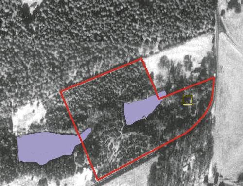
The photo below was taken on 21 January 1994. The image was extracted from a Color Infra-Red (CIR) digital orthophoto quadrangle provided by the U.S. Geological Survey. Each pixel represents 1 by 1 meters of earth.
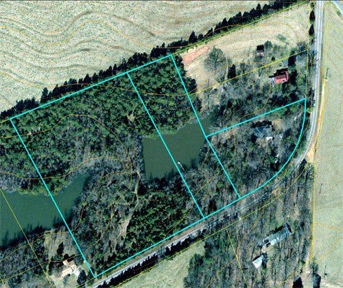
The 11-acre tract that defines Hilton Pond Center for Piedmont Natural History is outlined in red. Hilton Pond, constructed to control erosion in about 1960, is the smaller body of water highlighted in blue; a second impoundment (called "Nothilton Pond") lies partly on the property. The circa-1918 farmhouse that serves as the Center's office and lab is outlined in yellow; it is positioned at Lat 34º 58' 21" N, Long 81º 13' 25" W. Devinney Road forms the Center's southern border and turns northward toward the City of York; proceeding southwest it passes York Comprehensive High School and intersects with US 321 about one mile away. Visible in the southwest quadrant of the property are some of the two-plus miles of nature trails that meander around the property and that--in some cases--serve as mist net lanes for capturing birds. The 60-acre pine plantation north of the Center was clear-cut in 1995 (compare top photo with the one below, taken in about 2000); it is now in pasture used by beef cattle. In the photo below, the Center's several legally defined tracts are outlined in blue.
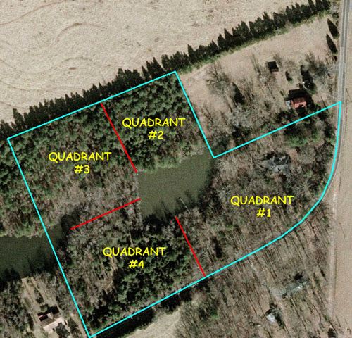
The next overflight photo to which we have access (below) was taken in late winter or early spring 2006, well before green-up; it shows more clearly the relative extent of leafless deciduous trees and evergreens. On this photo we have indicated in red the approximate borders for each of four unequal "quadrants" into which the property is divided for research and survey purposes. Quadrant borders roughly follow old fencerows that were established to keep livestock from wandering.
Hilton Pond Center continues to undergo natural vegetational succession and undoubtedly will look different when the next series of aerial photos is taken. |
|
Up to Top of Page Back to Introduction to Hilton Pond Current Weather Conditions at Hilton Pond Center |
|
Make direct donations on-line through
Network for Good: |
 |
|
LIKE TO SHOP ON-LINE?
Donate a portion of your purchase price from 500+ top on-line stores via iGive: |
 |
|
Use your PayPal account
to make direct donations: |
|
 post questions for The Piedmont Naturalist |
Join the |
Search Engine for |
|
|